See which parking lots need work first
SITEKEEPER rates every asphalt lot in your portfolio from 1 to 5 from open aerial imagery, shows the evidence behind each rating and ranks the lots to survey first. In Ontario and the United States.
A desktop screening, not an ASTM D6433 Pavement Condition Index. Lots that need it get a walked survey.
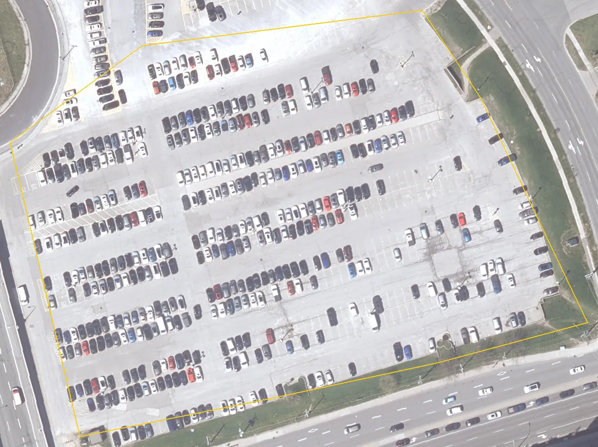
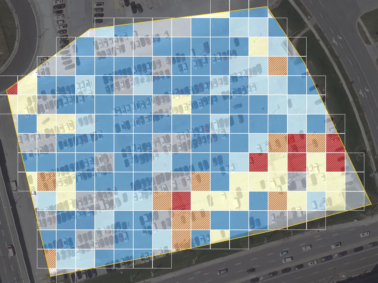
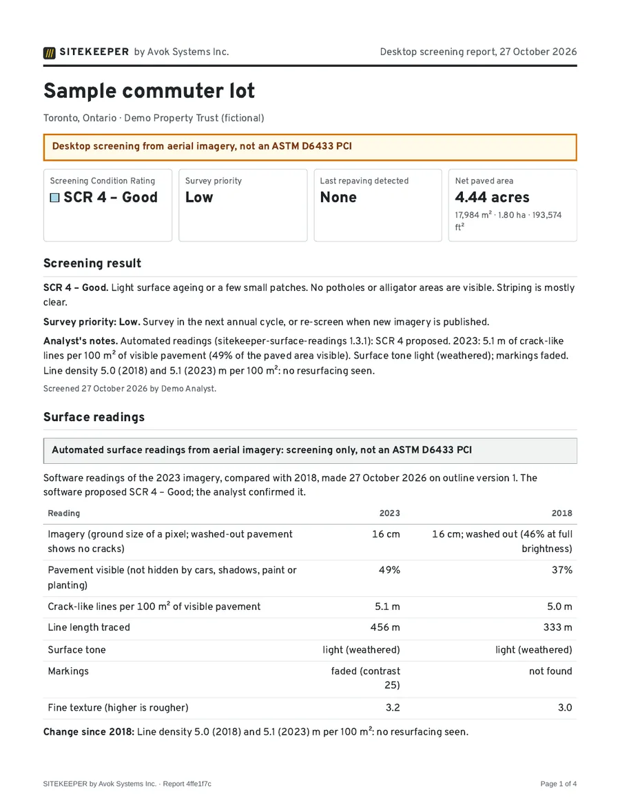
- Very few lines (as SCR 5)
- Few (as SCR 4)
- Moderate (as SCR 3)
- Many (as SCR 2)
- Very many (as SCR 1)
- Hidden by cars or shadow
Crack-like lines in each 10 m cell, read from Ontario’s 2023 aerial imagery at 16 cm per pixel. The lot as a whole reads SCR 4 – Good; the hatched cells show where to look first.
Drag the divider, or use the arrow keys.
Imagery: South Central Ontario Orthophotography Project 2018 and 2023. Contains information licensed under the Open Government Licence – Ontario.
- Database held in Canada
In Montréal. You own your data and can export all of it.
- Published method
Every rating has written criteria and stated limits.
- Open imagery, credited
Each source, its date and its licence, named.
- Independent of contractors
SITEKEEPER takes no revenue from paving work.
Every lot in the portfolio, ranked
The portal puts the lots that need work at the top, shows how much paved area sits at each rating and keeps the evidence for every rating a click away. Take it into your capital plan or GIS as CSV, GeoJSON or shapefile.
One scale for every lot
The same written 1 to 5 scale everywhere, so a lot in Mississauga and one in Indianapolis compare directly.
Evidence behind each rating
The imagery of every year, the lines traced and the analyst’s notes stay with the rating, and the report says how it was reached.
Surveys only where they pay
The survey priority says which lots need a walked ASTM D6433 survey now and which can wait for the next imagery.
- Sites
- 6
- Net paved area
- 20.3 acres
- High survey priority
- 3
Paved area by rating58% rated SCR 1 or 2
| Site, worst first | Acres | Screening | Priority | Last repaving |
|---|---|---|---|---|
| Retail plaza, north lot | 3.2 | SCR 1 – Very poor | High | 2008 |
| Distribution centre, truck court | 6.1 | SCR 2 – Poor | High | 2011 |
| Office park, lot B | 2.4 | SCR 2 – Poor | High | – |
| Grocery-anchored centre | 4.7 | SCR 3 – Fair | Medium | 2015 |
| Medical office, visitor lot | 1.1 | SCR 4 – Good | Low | 2019 |
| Industrial flex, east lot | 2.8 | SCR 5 – Very good | Low | 2023 |
How a lot gets its rating
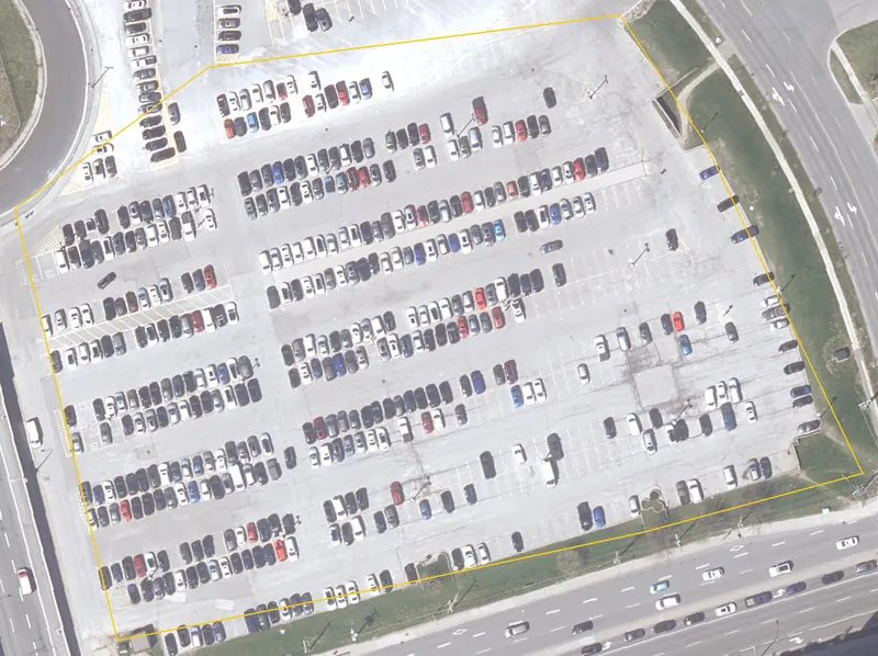
Outline the lot
Find the site by address and draw the paved area, or paste its coordinates. Islands and buildings are left out, and the area is given in square metres, hectares, acres and square feet.
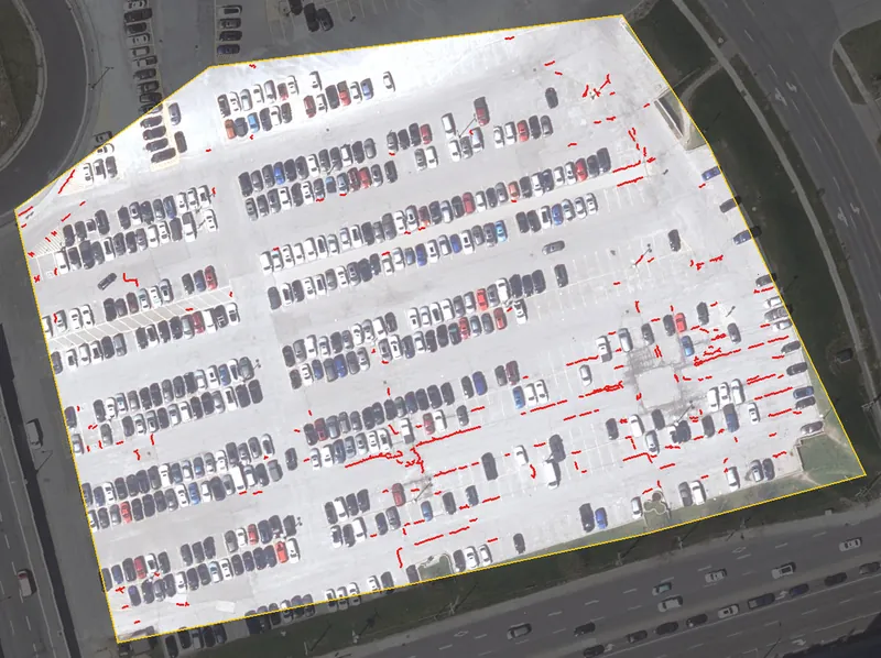
Read every year of imagery
SITEKEEPER clips the open aerial imagery of every year that covers the lot and measures crack-like lines, surface tone and markings in each. It proposes a rating and dates a resurfacing from the change in tone.
An analyst sets the rating
An Avok analyst checks the imagery, marks patches, potholes, ponding and faded markings, and sets the Screening Condition Rating and the survey priority. The analyst’s rating is the one on your report.
Survey the lots that need it
High-priority lots get a field survey by ASTM D6433 sample units, with photographs and an engineer’s sign-off. Reports, exports and quotes all come from the same data.
Five ratings, each written down
A rating means the same on every lot. Each one has written criteria, and its colour always comes with its number and word: the scale reads the same in greyscale and for colour-blind readers, and the two worst ratings are also hatched.
- SCR 5 – Very good
Surface looks uniform and dark. No potholes, patches, alligator areas or ponding are visible. Striping is clear. Often a recent paving or sealing.
- SCR 4 – Good
Light surface ageing or a few small patches. No potholes or alligator areas are visible. Striping is mostly clear.
- SCR 3 – Fair
Visible ageing over much of the surface, several patches, or isolated alligator areas or ponding. Striping is faded in places.
- SCR 2 – Poor
Alligator areas or patching over a large part of the surface, potholes visible, or ponding in several places. Striping is faded or missing over much of the lot.
- SCR 1 – Very poor
Alligator areas across most of the surface, several potholes or failed patches, and extensive ponding or debris. Striping is largely missing.
Years of history on every lot, before anyone visits
SITEKEEPER reads every year of open aerial imagery that covers a lot, so you see how it has aged and roughly when it was last resurfaced, without a flight or a site visit.
- Ontario
- 14 provincial imagery projects flown from 2013 to 2025, each region about every five years, at 16 to 20 cm per pixel.
- United States
- USDA NAIP across every state of the lower 48, flown about every other year at 30 cm to 1 m. Where a state’s terms allow commercial use, its own finer imagery too: 16 state and county programmes in 15 states and Washington, DC.
- 2013SCOOP
- 2014DRAPE
- 2015SWOOP, Algonquin
- 2016COOP
- 2017NWOOP
- 2018SCOOP
- 2019DRAPE
- 2020SWOOP
- 2021COOP
- 2022NWOOP
- 2023SCOOP
- 2024DRAPE
- 2025SWOOP
Read a full report before you buy
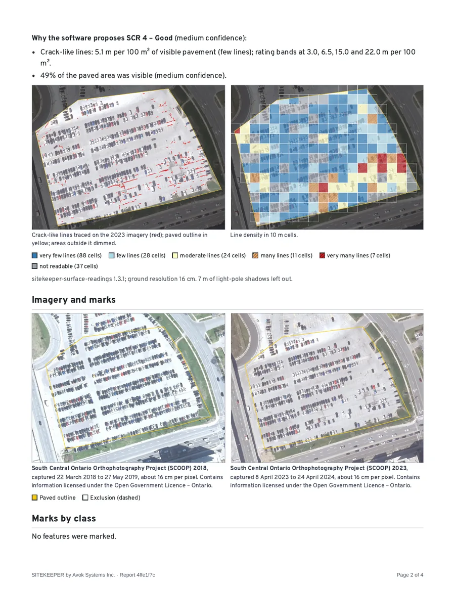
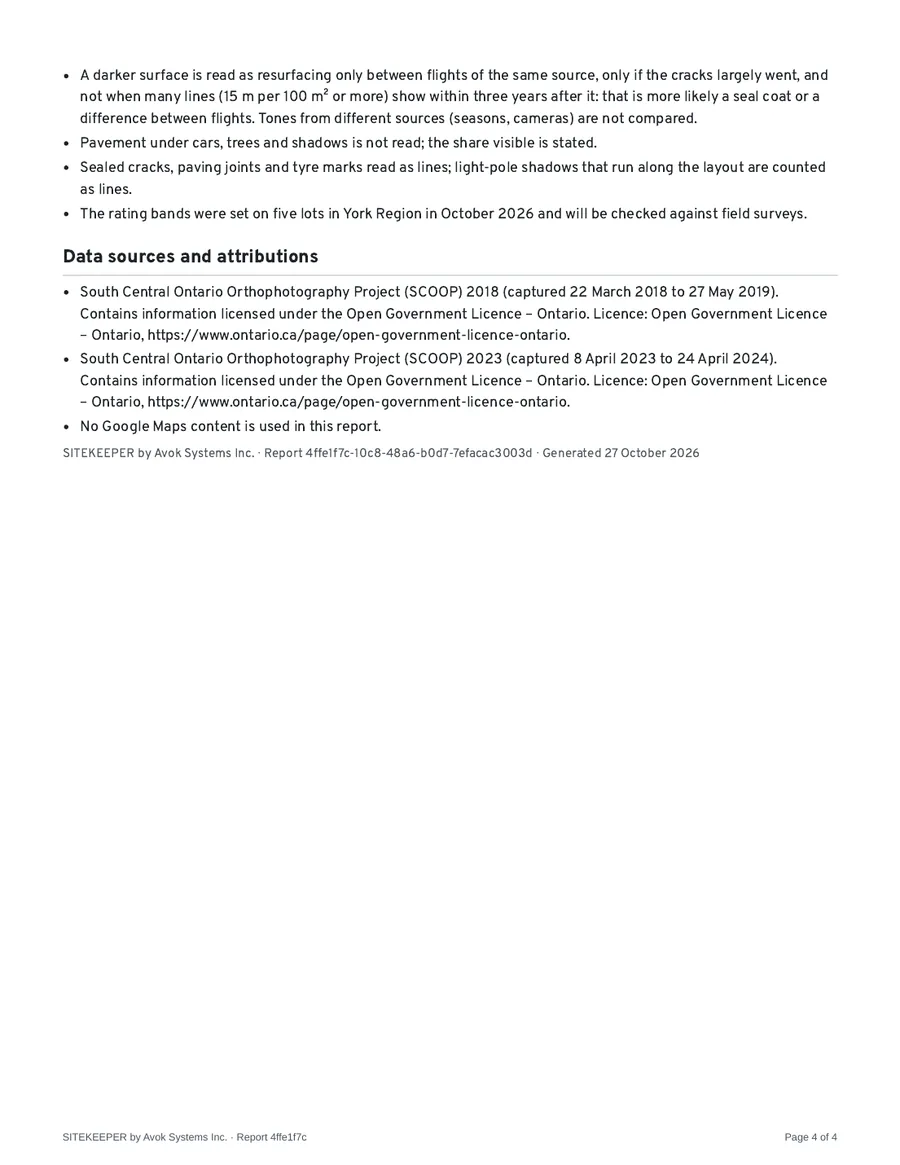
The sample is a real screening report for the commuter lot above: rating, survey priority, readings for each year of imagery, method, limitations and data sources. Only the client’s name is invented.
The rest of the site, from photos
Roofs, building envelope, lighting, signs, fences, drainage and landscaping are photographed on site and rated by a person on a written scale. They sit in the same register as the lots, coded to UNIFORMAT II, with a capital plan by year and the Facility Condition Index.
Roofs
UNIFORMAT II B3010, B3020
Building envelope
UNIFORMAT II B2010, B2020, B2030
Site lighting
UNIFORMAT II G4020
Signs, fences and furnishings
UNIFORMAT II G2040
Walkways, curbs and barriers
UNIFORMAT II G2030, G2020
Storm drainage
UNIFORMAT II G3030
Landscaping
UNIFORMAT II G2050
Your data stays yours
- You own your data, and you can export all of it at any time at no charge, as CSV, GeoJSON, shapefile and PDF.
- The SITEKEEPER database is held in Canada (Montréal). Files such as photos, clipped imagery and reports are kept in Cloudflare R2 object storage, which does not guarantee a location in Canada.
- SITEKEEPER takes no revenue from paving contractors.
- Faces and licence plates in field photos are pixelated on the device before upload.
Built for owners of many lots
REITs and retail landlords
One rating for every lot in the portfolio, with the lots to survey first at the top of the list.
Parking authorities
Every lot rated on the same written scale, and re-screened when new imagery is published.
Campuses and hospitals
Plan resurfacing across many small lots without walking each one first.
Municipalities
Screen municipal lots between condition surveys, and take the results into your GIS as GeoJSON or shapefile.
Defence and public-sector sites
The database is held in Canada, by a Canadian company: Avok Systems Inc., Toronto.
Questions
Is the rating a Pavement Condition Index?
No. The Screening Condition Rating is a desktop rating from aerial imagery on a scale of 1 to 5. A Pavement Condition Index comes from a walked survey by the ASTM D6433 method. SITEKEEPER reports the two separately and never shares their wording or colours.
How recent is the imagery?
Ontario flies each region about every five years (2013 to 2025 so far). The USDA flies NAIP in each state about every other year, and some states fly their own finer imagery. Every report names its imagery and when it was captured.
What can a screening not see?
Cracks narrower than about a pixel (7.5 to 20 cm) unless they show as a dark line, anything under parked cars, trees or shadows, and detail lost where the imagery is washed out. Each report states how much of the lot was visible.
Does SITEKEEPER cover more than the pavement?
Yes. Roofs, building envelope, lighting, signs, fences, drainage and landscaping are inspected with photos taken on site and rated 1 to 5 by a person, in ASTM E2018 terms of good, fair and poor. Those ratings are reported apart from the pavement scales, and no software rates them on its own.
Where is my data held?
The database is held in Canada (Montréal). Photos, clipped imagery and reports are kept in Cloudflare R2 object storage, which does not guarantee a location in Canada.
What does it cost?
Prices are being finalised. Request a quote and we reply by email with prices for your sites.
Send us your list of lots
Tell us where the sites are and what you need. We reply by email with a quote.